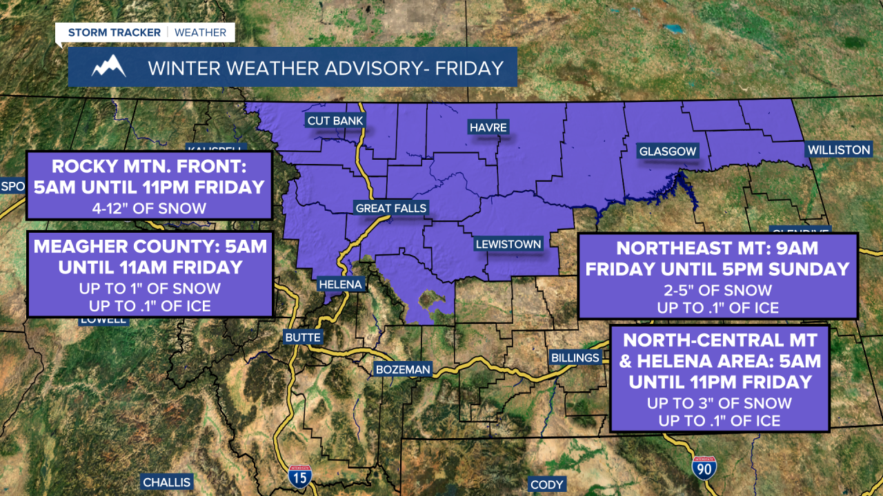
A WINTER WEATHER ADVISORY is in effect for the Rocky Mountain Front until 10pm Thursday and from 5am until 11pm Friday.
A WINTER WEATHER ADVISORY is in effect for the Meagher County valleys from 5am until 11am Friday.
A WINTER WEATHER ADVISORY is in effect for all of north-central Montana and the Helena area from 5am until 11pm Friday.
A WINTER WEATHER ADVISORY is in effect for northeastern Montana from 9am Friday until 5pm Sunday.

A WINTER STORM WATCH is in effect for the Rocky Mountain Front from 2am Saturday until 5am Sunday and for portions of the Hi-Line from 5am Saturday until 5am Sunday.
A WINTER WEATHER ADVISORY is in effect for the Great Falls and Fort Benton area from 5am Saturday until 5am Sunday.

We are going to have mostly cloudy to overcast skies tonight with scattered snow, freezing rain, and rain showers around, especially before midnight and especially in the mountains and along the Hi-Line. Up to an inch of snow and a light glaze of ice is possible in locations that do see some of this precipitation tonight. We are also going to have a wide range of temperatures tonight as lows are going to range from the low teens to the mid 30s, with the warmest temperatures around Helena.
For tomorrow, a wintry mix of snow, freezing rain, and rain is likely, with primarily snow expected along the Hi-Line and the Rocky Mountain Front, a mixture of freezing rain, snow, and rain expected south of the Hi-Line and east of the Rocky Mountain Front in north-central Montana, and more rain than freezing rain and snow expected around the Helena area. This precipitation will begin to develop around sunrise and will become more widespread during the rest of the morning and stick around all the way through the evening. This means that the morning commute will be slick in some areas and the evening commute will be slick in most areas, so please be careful when driving.
We will then get a bit of a lull in the precipitation tomorrow night, but the next round of wintry precipitation will arrive later tomorrow night. On Saturday, snow is likely throughout the day along the Hi-Line and the Rocky Mountain Front. South of the Hi-Line and east of the Rocky Mountain Front, a wintry mix of rain, freezing rain, and snow is likely initially, but the precipitation will transition over to all snow later in the day as a cold front passes through our area. Heavier snow bands are also possible with the passage of the cold front.
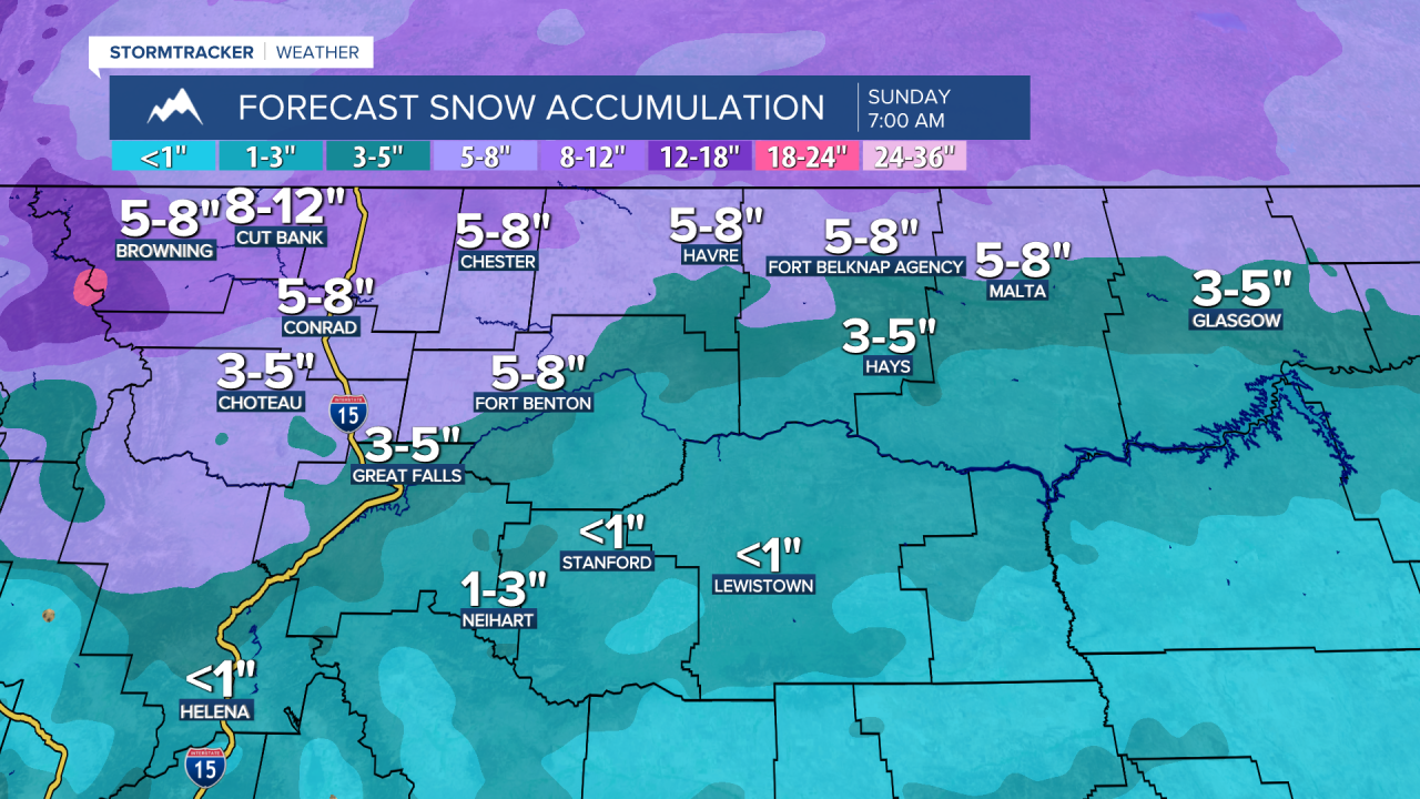
Right now, it looks like the heaviest snow amounts through Sunday morning will be along the Rocky Mountain Front and along western portions of the Hi-Line, including in Havre and Cut Bank, where 5-12” of snow is expected. In the Glacier National Park area, up to two feet of snow accumulation is possible through Sunday morning. South of the Hi-Line and east of the Rocky Mountain Front in north-central Montana, 1-6” of snow accumulation is expected through Sunday morning, with some of that accumulation occurring tomorrow and then some more accumulation expected later on Saturday. Around Helena, a coating to 3 inches of snow accumulation is expected through Sunday morning, with most of that accumulation occurring Saturday afternoon through Saturday night.


There is also going to be ice accumulation with this storm system, especially from Friday morning through midday Saturday. The highest ice amounts look to be in central Montana and southern portions of north-central Montana, including around Great Falls, Helena, and Lewistown, where up to .1” of ice is possible, although isolated locations may receive up to .15” of ice.


We are also going to continue to have a wide range of temperatures tomorrow and Saturday as highs are going to range from the upper teens to the mid 40s, with the coldest temperatures along western portions of the Hi-Line and the warmest temperatures around Helena. It is also going to be breezy in some areas on Saturday as sustained wind speeds are going to be between 10 and 25 mph, so blowing snow will be an issue.
On Sunday, we are going to have mostly to partly cloudy skies with some lingering snow showers around, generally during the morning, as this storm system leaves our area. It is also going to be cold on Sunday as highs are going to be in the teens and in most locations, and lows Sunday night will be in the -0s and 0s in a lot of locations.
We are then going to have partly cloudy skies and mostly dry conditions on Monday and Tuesday as high pressure is going to be in control of our weather. There is also going to be a little breeze around on these two days as sustained wind speeds are going to be between 5 and 20 mph. We are also going to continue to have below average temperatures on these two days as highs are going to range from the mid teens to the mid 30s on Monday, with the coldest temperatures along the Hi-Line, and highs are going to be in the 20s and 30s on Tuesday.
On Wednesday, we are going to have partly cloudy skies with a chance of snow showers, especially during the evening, as the next disturbance begins to approach our area. There is then going to be some scattered snow around on Thanksgiving, especially during the morning, as this disturbance passes through our area. We are also going to have mostly cloudy skies on Thanksgiving.
The temperatures are also going to cool down some over these two days as highs are going to be in the 20s and low to mid 30s on Wednesday and the 20s and mid to upper teens on Thursday.


