A HEAT ADVISORY is in effect for eastern Montana until 9pm Saturday. High temperatures are going to be in the mid to upper 90s, and a few locations may even crack the century mark. Dew points are also going to be in the 50s, so it is going to feel a bit muggy.

A LAKE WIND ADVISORY is in effect for Fort Peck Lake until 12am Saturday. Sustained wind speeds are going to be between 20 and 30 mph, and wind gusts up to 45 mph are going to be possible at times.

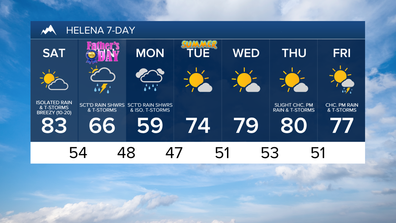
We are going to have partly cloudy skies tonight with a few isolated rain showers and thunderstorms around, generally in northeastern Montana and along the Rocky Mountain Front. A few of these thunderstorms may also be severe with damaging wind gusts and/or large hail. It is also going to be mild/warm tonight as lows are going to be in the mid to upper 50s and low to mid 60s in most locations. There is also going to be a bit of a breeze around tonight as sustained wind speeds are going to be between 5 and 20 mph.
For tomorrow, we are going to have increasing clouds with a chance of rain showers and thunderstorms, generally during the afternoon and evening. A few of these thunderstorms may also be severe with damaging wind gusts and/or large hail. We are also going to have a wide range of temperatures tomorrow as highs are going to be in the 70s and 80s in central Montana, and the 90s and low 100s in eastern Montana. It is also going to be breezy tomorrow as sustained wind speeds are going to be between 10 and 20 mph.
We are then going to have partly to mostly cloudy skies tomorrow night with some scattered rain showers and thunderstorms around, especially after midnight, as a storm system begins to approach our area. There are then going to be scattered rain showers and thunderstorms around on both Sunday and Monday as this storm system passes through our area. Some of these thunderstorms may also be strong with heavy rainfall, small to medium-sized hail, gusty winds, and/or frequent lightning. We are also going to have partly to mostly cloudy skies on Sunday, and mostly cloudy skies on Monday.
The temperatures are also going to be a lot cooler on Sunday and Monday as highs on Sunday are going to be in the 60s and low to mid 70s in most locations, and highs on Monday are going to be in the mid to upper 50s and low to mid 60s in most locations. It is also going to be breezy on Monday as sustained wind speeds are going to be between 10 and 20 mph.
Also, the thunderstorms that we see over the next few days may produce a lot of rain in a short period of time, so flash flooding is possible. Flooding is also possible along the Rocky Mountain Front this weekend and early next week due to the combination of rainfall and snowmelt. If you are going to be on or near any water over the next several days, just be mindful of the water flow and water level.
Mostly sunny skies and mostly dry conditions are then expected on Tuesday and Wednesday as high pressure is going to be in control of our weather. The temperatures are also going to warm up some over these two days as highs are going to be in the 70s on Tuesday and the mid to upper 70s and low 80s on Wednesday. There is also going to be a bit of a breeze around on these two days as sustained wind speeds are going to be between 10 and 20 mph.
We are then going to have increasing clouds with a couple isolated PM rain showers and thunderstorms around on Thursday, and a few scattered PM rain showers and thunderstorms around on Friday as we return to an unsettled weather pattern. The temperatures on these two days are also going to be near to a little bit above average for this time of year as highs are going to be in the mid to upper 70s and low to mid 80s. There is also going to be a little bit of a breeze around on these two days as sustained wind speeds are going to be between 10 and 15 mph.