A FIRE WEATHER WATCH is in effect from 12pm to 10pm Wednesday/Thursday for northwestern Montana and from 12pm Thursday to 12am Friday for north-central Montana. Critical fire weather conditions are expected due to the combination of hot temperatures, breezy conditions, and low relative humidity, so please do your part to not start any new fires.

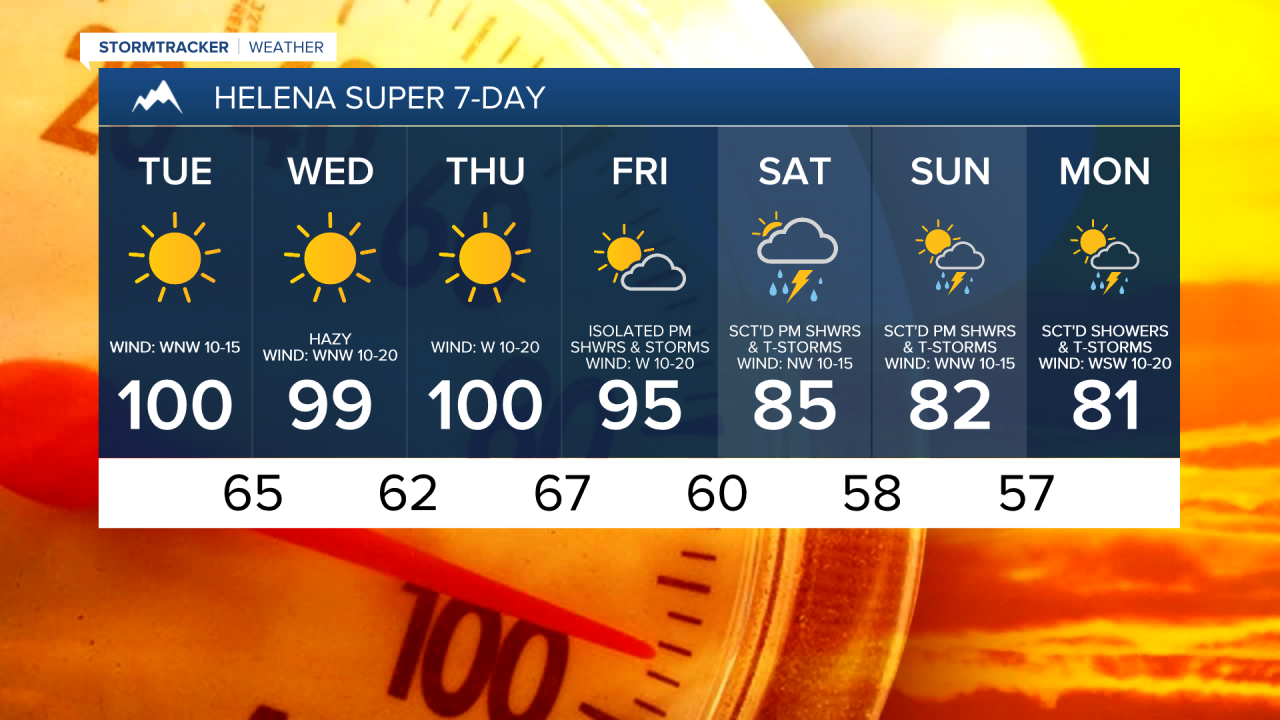
We are going to have clear skies and mild temperatures tonight as lows are going to be in the mid to upper 50s and low 60s. For tomorrow, we are going to have lots of sunshine and very hot temperatures as highs are going to be in the mid to upper 90s and low 100s. It is also going to be breezy tomorrow afternoon/evening along/just east of the Rocky Mountain Front as sustained wind speeds are going to be between 10 and 25 mph.
A cold front is then going to clip north-central and eastern Montana late tomorrow night/Wednesday morning. This means that we are going to have partly cloudy to mostly clear skies late tomorrow night/Wednesday morning in north-central and eastern Montana as the cold front passes through. A couple isolated showers and thunderstorms are also possible late tomorrow night/Wednesday morning in northeastern Montana. The wind is also going to pick up along/behind the cold front, and it will be a bit breezy in north-central Montana (gusts up to 30 mph) and windy in eastern Montana (gusts up to 50 mph) late tomorrow night/Wednesday morning.
Thanks to this cold front, it is going to be cooler on Wednesday than it is going to be tomorrow in north-central and eastern Montana as highs are going to be in the mid to upper 80s and low 90s. However, around the Helena area, it is going to be very hot again on Wednesday as highs are going to be in the 90s to around 100°. We are also going to have lots of sunshine again on Wednesday, especially during the afternoon/evening. Widespread haze is also expected on Wednesday as the cold front brings some smoke from the Canadian wildfires back into our area. Gusty winds are also expected Wednesday afternoon/evening around the Helena area and in eastern Montana as wind gusts up to 40 mph are possible.
Very high fire danger is then expected on Thursday as it is going to be very hot (highs in the mid to upper 90s and low 100s) and it is going to be breezy (sustained wind speeds between 10 and 25 mph). We are also going to have lots of sunshine and dry conditions on Thursday, which means low relative humidity (as low as 7% to 15%). Please do your part to not start any new fires on Thursday!
On Friday, it is still going to be hot, but it will be a little cooler than it is going to be on Thursday as highs are going to be in the 90s in most locations. It is also going to be breezy again on Friday as sustained wind speeds are going to be between 10 and 25 mph, and wind gusts up to 40 mph are possible. We are also going to have partly cloudy to mostly sunny skies on Friday with a few isolated showers and thunderstorms around, generally in the mountains.
A pattern change to cooler, cloudier, and wetter weather is then expected this weekend as an upper-level trough is going to be in control of our weather. It is going to be cooler this weekend as highs are going to be in the 70s and low to mid 80s, and it is going to be cloudier this weekend as we are going to have partly to mostly cloudy skies. It is also going to be wetter this weekend as there are going to be scattered showers and thunderstorms around, especially during the PM hours. This cooler, cloudier, and wetter weather pattern is also expected for the beginning part of next week.