


A WINTER WEATHER ADVISORY is in effect until 6am Saturday for portions of north-central Montana and until 6am Sunday for the West Glacier area.

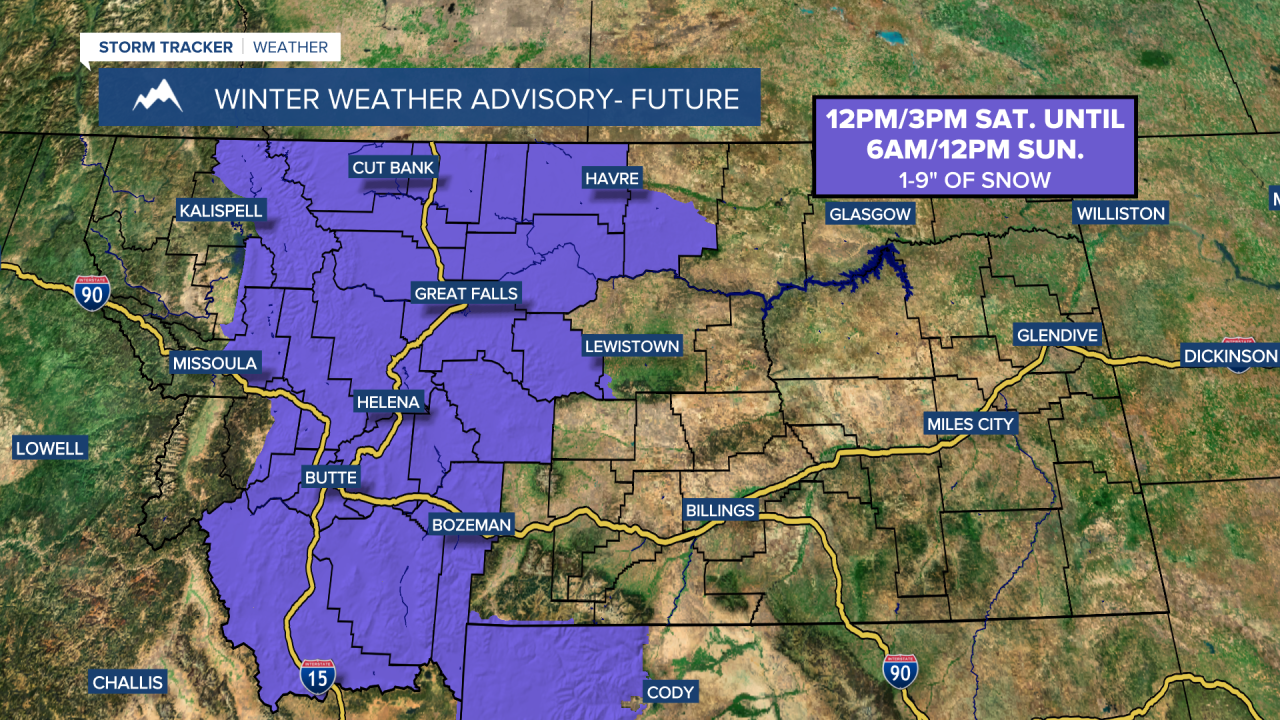
A WINTER WEATHER ADVISORY is in effect for portions of western and central Montana from 12pm/3pm Saturday until 6am/12pm Sunday.
A WINTER STORM WARNING is in effect for a lot of eastern Montana and eastern portions of north-central Montana from 3pm/6pm Saturday until 12am/6am Monday.
A WINTER STORM WATCH is in effect for portions of southeastern Montana from 6pm Saturday until 12am Monday.

There are going to be areas of snow around tonight in north-central Montana, especially after midnight, and there are going to be a few snow/rain showers around the Helena area tonight, generally before midnight. We are also going to have mostly cloudy to overcast skies tonight. It is also going to be cold tonight as lows are going to be in the teens and 20s. There is also going to be a little bit of a breeze around in some areas tonight as sustained wind speeds are going to be between 5 and 20 mph.
For tomorrow, there are going to be some scattered areas of snow around during the morning, especially along the Hi-Line. Snow will then become more widespread as we go through tomorrow afternoon and into tomorrow evening as a storm system begins to impact our area. A little rain is also possible around the Helena area with the initial onset of precipitation later tomorrow. Widespread snow is then likely tomorrow night. There is also going to be widespread snow around on Sunday, but the snow will gradually taper off and lighten up as the day goes on. Also, some of the snow that falls later on tomorrow and tomorrow night is going to be heavy, so please be careful when traveling.
Widespread snow accumulation is expected this weekend, with basically all locations in north-central and central Montana receiving between 2 and 9 inches of snow accumulation by Sunday evening, with isolated higher amounts possible. The heaviest and most widespread snow accumulation will occur tomorrow evening through Sunday morning, and this is when the road conditions will be the worst this weekend.


It is also going to be cold this weekend as highs are going to be in the 20s and 30s tomorrow and the 20s and upper teens on Sunday. Breezy conditions are also expected tomorrow, especially in locations east of I-15, as sustained wind speeds are going to be between 10 and 25 mph, and this wind will cause there to be areas of blowing and drifting snow around. It is then going to be a bit breezy in some areas on Sunday as sustained wind speeds are going to be between 10 and 20 mph.
There are then going to be some scattered snow showers around on Monday, especially during the morning. We are also going to have partly to mostly cloudy skies on Monday. It is also going to continue to be cold on Monday as highs are going to range from the upper teens to the mid 30s.
We are then going to have partly to mostly cloudy skies on Tuesday with a chance of PM snow and rain showers around the Helena area and a slight chance of PM rain and snow showers in north-central Montana as a disturbance passes through our area. Partly to mostly cloudy skies and mostly dry conditions are then expected on Wednesday. The temperatures are also going to warm back up some over these two days as highs are going to be in the 20s, 30s, and low to mid 40s on Tuesday, and the 30s and 40s on Wednesday. There is also going to be a bit of a breeze around in some areas on these two days as sustained wind speeds are going to be between 10 and 20 mph.
Another round of rain and snow is then possible on Thursday as another disturbance passes through our area. It is also going to be cool and a little breezy on Thursday as highs are going to be in the mid to upper 30s and low to mid 40s, and sustained wind speeds are going to be between 5 and 20 mph.


