The second winter storm of the season dropped several inches of snow on the area, leaving roads slippery and the ground covered.
As of Wednesday afternoon we're still tracking some light snow bands in the area, but additional accumulations will be less than an inch.
In general, our skies will be clearing overnight as high pressure builds in.
On the positive side, this means an end to our snowfall. On the other hand, it means some very low temperatures Wednesday night into Thursday morning.
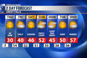
Many of us, especially places with a good amount of snow on the ground, will see our temperatures fall all the way into the single digits. A few warmer spots will stay in the teens.
Thursday isn't looking very warm either. Highs will be right around the freezing mark, despite sunny skies.
WINTER WEATHER RESOURCES:
- STORMTracker Weather page
- Live interactive radar
- STORMTracker on Facebook
- Montana webcams (MDT site)
- Road Conditions (MDT site)


