
A RED FLAG WARNING is in effect for portions of the Hi-Line until 9pm Friday.

Widespread haze is expected through the weekend as smoke from wildfires burning locally, in Canada, and in the Pacific Northwest continues to impact our area. Periods of smoke are also expected this weekend, with smoky conditions expected tonight and Sunday in southwestern Montana. Tomorrow, that smoke will be more widespread, impacting southwestern, south-central, and portions of north-central Montana. In areas where it is smoky, the air quality will at least be unhealthy for sensitive groups, if not unhealthy for everyone, so keep an eye on the air quality this weekend if you are going to be outdoors at all.
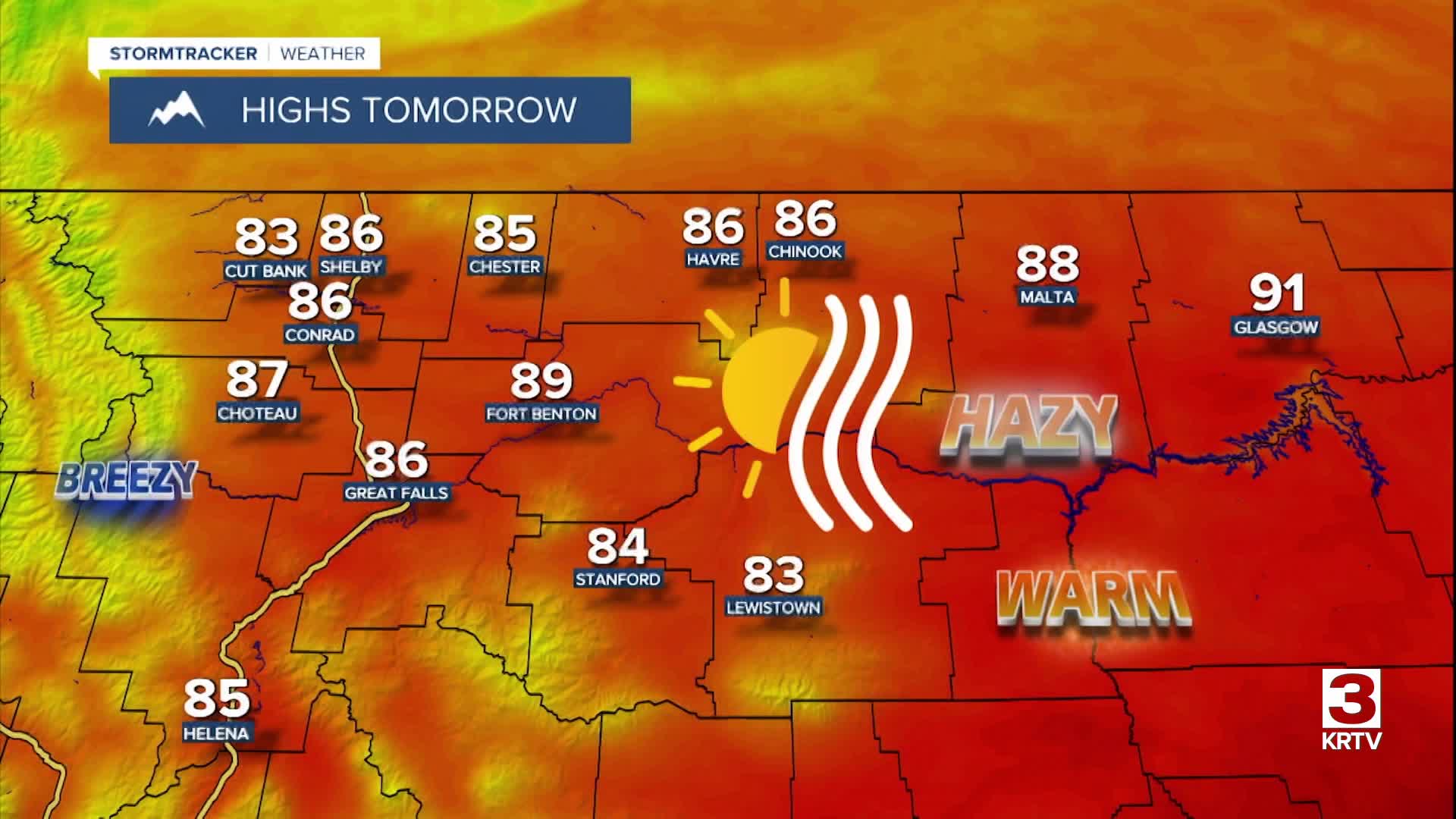
We are going to have clear skies, dry conditions, little wind, and pleasant temperatures tonight as lows are going to be in the mid to upper 40s and low to mid 50s. We are then going to have lots of sunshine and mainly dry conditions tomorrow in north-central Montana, and we are going to have increasing clouds with a few PM showers and thunderstorms tomorrow around the Helena area. It is also going to be very warm tomorrow as highs are going to be in the mid to upper 80s and low 90s in most locations, and it will be breezy tomorrow along the Rocky Mountain Front and around the Helena area as sustained wind speeds are going to be between 10 and 20 mph.

On Sunday, there are going to be a few showers and thunderstorms around as a disturbance passes through our area. We are also going to have partly to mostly sunny skies and warm temperatures on Sunday as highs are going to be in the 80s in most locations. It is also going to be a bit breezy on Sunday as sustained wind speeds are going to be between 10 and 20 mph.
Mostly sunny skies and dry conditions are then expected on Monday as high pressure is going to be in control of our weather. It is also going to be breezy on Monday as sustained wind speeds are going to be between 10 and 25 mph, and wind gusts up to 40 mph are possible. Also, highs on Monday are going to be in the upper 80s and low to mid 90s in most locations.
On Tuesday, we are going to have partly cloudy skies with a few showers and thunderstorms around as a cold front passes through our area. It is also going to be breezy and cooler on Tuesday as sustained wind speeds are going to be between 10 and 20 mph, and highs are going to be in the 80s in most locations.
Lots of sunshine and dry conditions are then expected on Wednesday, Thursday, and Friday as an upper-level ridge is going to be in complete control of our weather. The temperatures are also going to warm up some over these three days as highs are going to be in the mid to upper 80s and low 90s on Wednesday, and highs are going to be in the 90s on Thursday and Friday. There is also going to be a little breeze around on Wednesday and Thursday as sustained wind speeds are going to be between 5 and 20 mph.
