There are going to be scattered showers and thunderstorms around this evening and tonight as a disturbance passes through our area. The main batch of precipitation will work its way towards the east-northeast as the night goes on, with clearing skies and just a few scattered showers and thunderstorms behind the main batch of precipitation. A few of the thunderstorms that we see this evening and early tonight may also be severe with damaging winds (58+ mph gusts) and/or large hail (1+” in diameter). Heavy rainfall, frequent lightning, small to medium-sized hail, and/or gusty winds are also possible with all the thunderstorms that develop.

It is also going to be mild tonight as lows are going to be in the mid to upper 50s and low 60s in a lot of locations. There is also going to be a bit of a breeze around in some locations tonight as sustained wind speeds up to 20 mph are possible. Hazy skies are also expected tonight, especially in locations east of I-15.
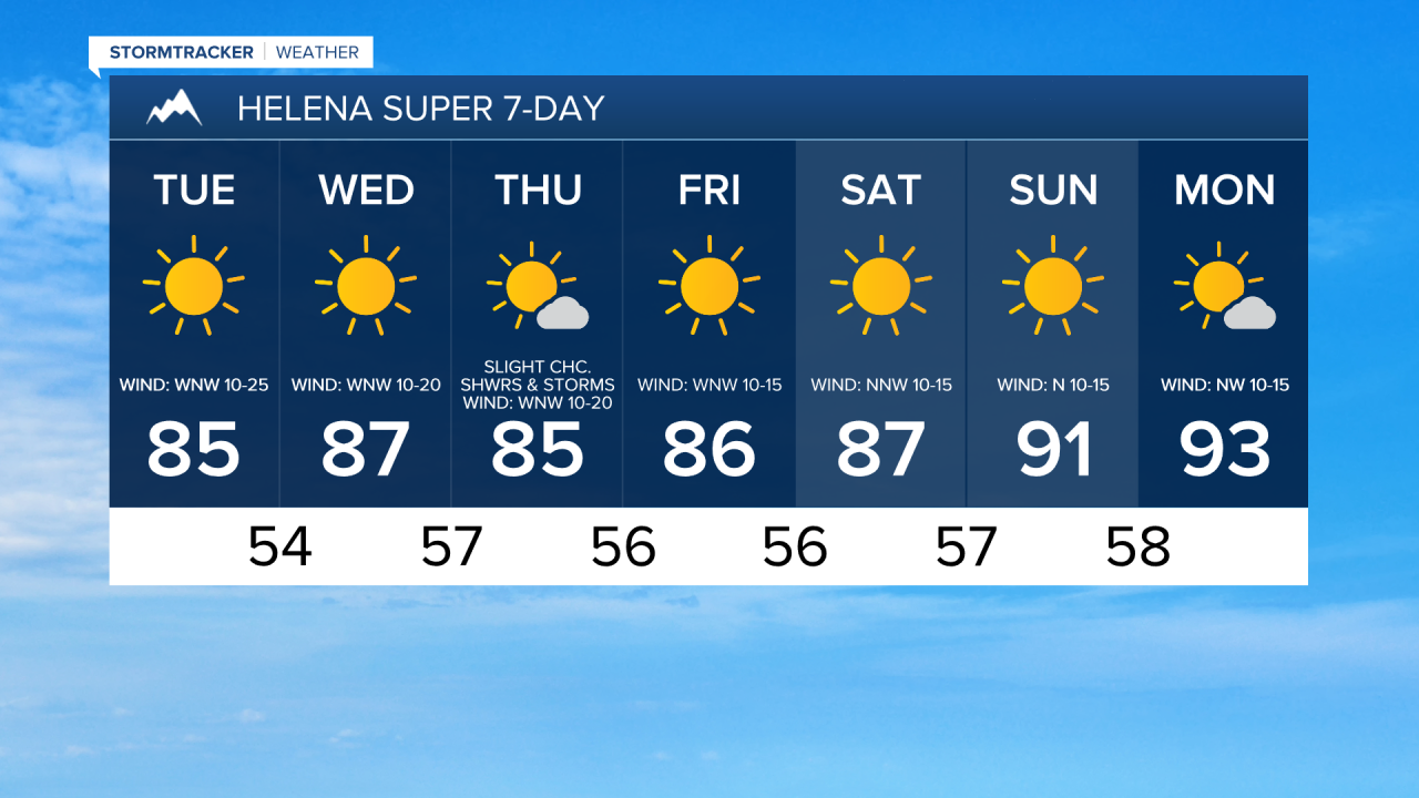
For tomorrow, we are going to have partly cloudy to mostly sunny skies with a few scattered showers and thunderstorms around, especially along the Hi-Line. We are also going to have hazy skies again tomorrow, but the haze should diminish some as the day goes on. It is also going to be cooler tomorrow than it was today as highs are going to be in the mid to upper 70s and low to mid 80s in most locations. Gusty winds are also expected tomorrow as wind gusts up to 50 mph are possible along the Rocky Mountain Front, and wind gusts up to 40 mph are possible east of the Rocky Mountain Front, and this wind is going to be coming out of the west.
On Wednesday and Thursday, we are going to have mostly sunny skies with some isolated showers and thunderstorms around, mainly along the Hi-Line and mainly during the PM hours, as a couple disturbances pass by our area to the north. It is also going to be warm on these two days as highs are going to be in the upper 70s and low to mid 80s in most locations. Breezy conditions are also expected on these two days as sustained wind speeds are going to be between 10 and 25 mph.
We are then going to have a chance to see a few scattered showers and thunderstorms on Friday, generally in locations east of I-15. We are also going to have mostly sunny skies and pleasant temperatures on Friday as highs are going to be in the mid to upper 70s and low to mid 80s. It is also going to be a bit breezy on Friday as sustained wind speeds are going to be between 10 and 20 mph.
For this weekend, we are going to have mostly sunny skies and mostly dry conditions (just a couple isolated showers and thunderstorms around). The temperatures are also going to warm up some this weekend as highs are going to be in the upper 70s and low to mid 80s on Saturday and the 80s and low 90s on Sunday.