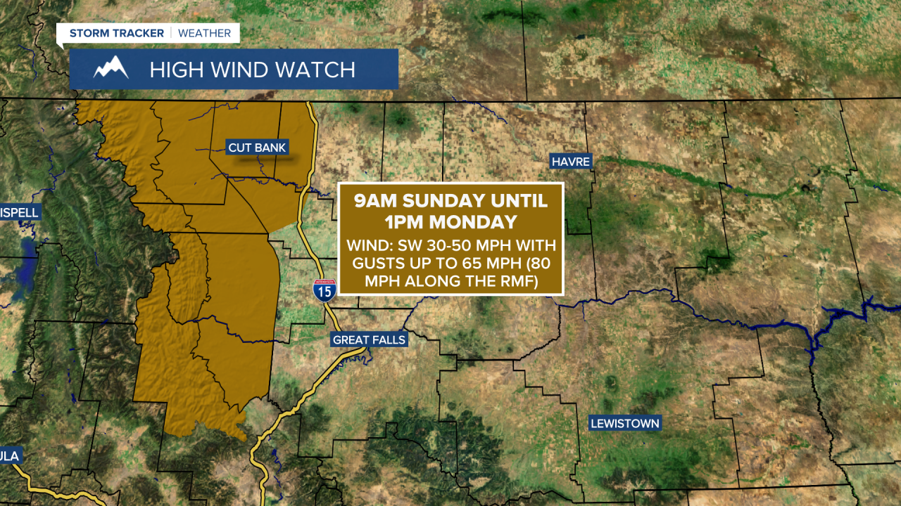
A HIGH WIND WATCH is in effect for the Rocky Mountain Front, the adjacent plains, and the Cut Bank area from 9am Sunday until 1pm Monday.
We are going to have partly cloudy to mostly clear skies and cool temperatures tonight as lows are going to be in the mid to upper 20s and low to mid 30s in most locations. It is also going to be windy tonight along the Rocky Mountain Front as sustained wind speeds are going to be between 20 and 35 mph, and it is going to be a bit breezy tonight in some areas east of the Rocky Mountain Front as sustained wind speeds are going to be between 10 and 20 mph.
For this weekend, it is going to be very windy along the Rocky Mountain Front and in the adjacent plains as sustained wind speeds are going to be between 25 and 50 mph, and wind gusts over 70 mph are possible. East of the Rocky Mountain Front, we are going to have gusty winds around this weekend as sustained wind speeds in a lot of locations are going to be between 10 and 30 mph, and wind gusts up to 50 mph are possible. In the Helena valley, there is just going to be a little breeze (5-20 mph) around this weekend. Sunday will be the windier day of the weekend for everyone.
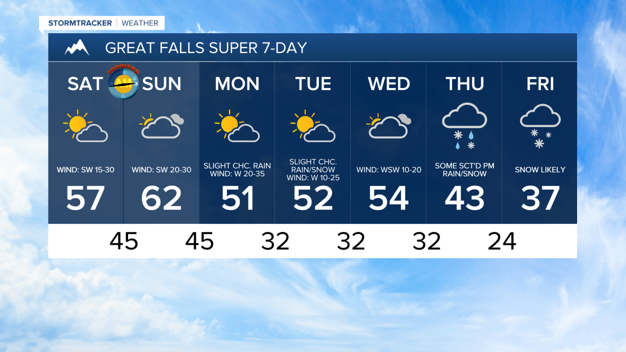
It is also going to be mild this weekend as highs are going to be in the 50s and mid to upper 40s tomorrow and the 50s and low to mid 60s on Sunday. We are also going to have partly to mostly cloudy skies and dry conditions this weekend as high pressure is going to be in control of our weather.
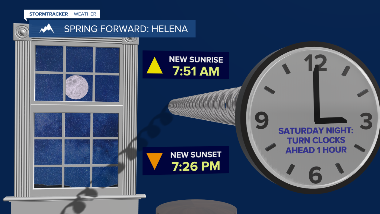
Just a reminder, Daylight Saving Time begins this weekend. Before you go to bed Saturday night, make sure you set your clocks forward one hour! On Sunday, the new sunrise in Great Falls will be at 7:49am and the new sunset will be at 7:22pm. In Helena, on Sunday, the new sunrise will be at 7:51am and the new sunset will be at 7:26pm. This is also a good weekend to change the batteries in your smoke detectors and carbon monoxide detectors!
On Monday, a cold front is going to pass through our area so there are going to be a few rain and snow showers around, generally in the mountains and along the Hi-Line, and it will be cooler than it will be this weekend as highs are going to be in the 40s and low 50s in most locations. It is also going to be windy on Monday as sustained wind speeds in a lot of locations are going to be between 15 and 35 mph, and wind gusts up to 60 mph are possible.
We are then going to have partly to mostly cloudy skies on Tuesday with a few rain and snow showers around, especially in the mountains, as another disturbance passes through our area. Wednesday will then be mostly cloudy with some isolated rain and snow showers around, generally in the mountains, as we are going to be in between disturbances. We are also going to continue to have above average temperatures on these two days as highs are going to be in the mid to upper 40s and low to mid 50s in most locations. It is also going to be breezy in some areas on these two days as sustained wind speeds are going to be between 10 and 25 mph.
A storm system is then going to bring cooler temperatures and widespread precipitation to our area for the end of next week. On Thursday, we are going to have developing rain/snow, generally during the second half of the day. There are then going to be areas of snow around Thursday night and Friday as this storm system passes through our area. The temperatures are also going to cool down some over these two days as highs are going to be in the upper 30s, 40s, and low to mid 50s on Thursday and the 30s on Friday.