A FLOOD ADVISORY is in effect for all of northeastern Montana and most of north-central Montana until Wednesday afternoon/evening. Minor flooding due to snowmelt is occurring and will continue to occur through at least tomorrow.

It has been another windy day, but the wind will weaken some as we go through this evening and tonight. East of the Rocky Mountain Front, it is going to be breezy tonight as sustained wind speeds are going to be between 10 and 25 mph. Along the Rocky Mountain Front, it is going to be gusty tonight, as sustained wind speeds are going to be between 15 and 30 mph.
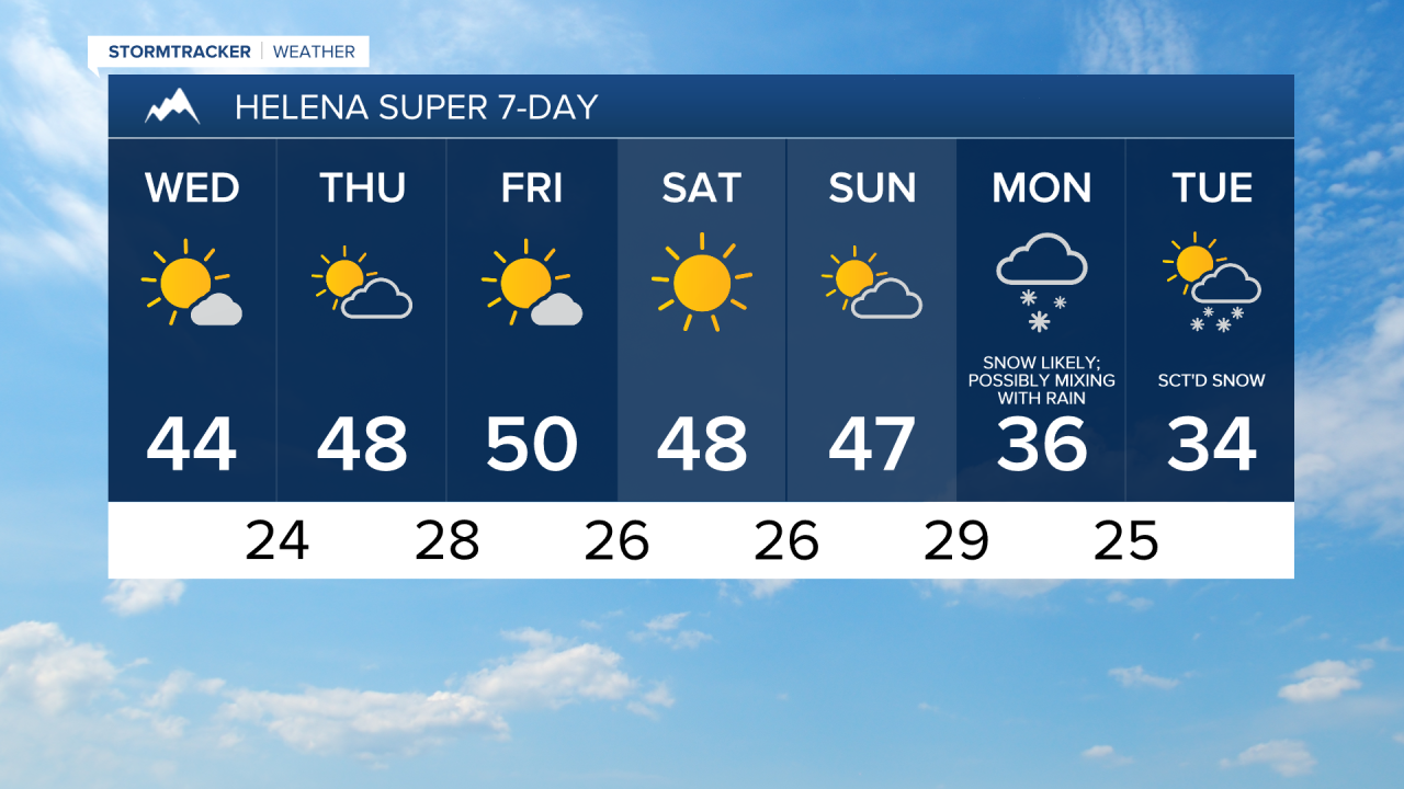
Around Helena, we are going to have mostly to partly cloudy skies tonight with some scattered snow and rain showers around, especially in the mountains, as a disturbance continues to impact our area. At and above mountain pass level, a coating-2” of snow is expected. Due to this snow, roads may be slippery in some areas tonight and tomorrow morning, including along portions of I-15 south of Helena, along US 12 in the Deep Creek area, and over MacDonald Pass and Rogers Pass, so please use extreme caution when driving. In the lower elevations, little (a trace) to no snow accumulation is expected tonight.
In north-central Montana, we are going to have mostly clear skies and mainly dry conditions tonight. It is also going to be cool tonight as lows are going to be in the mid to upper 20s and low to mid 30s in most locations.
For tomorrow, we are going to have mostly sunny skies and pleasant temperatures as highs are going to be in the 40s and low 50s in most locations. There is also going to be less wind around tomorrow, but it is still going to be breezy east of the Rocky Mountain Front as sustained wind speeds are going to be between 10 and 25 mph. Along the Rocky Mountain Front, it is going to be gusty tomorrow as sustained wind speeds are going to be between 15 and 30 mph.
We are then going to have partly cloudy skies and warmer temperatures on Thursday as highs are going to be in the mid to upper 40s and low to mid 50s around Helena and highs are going to be in the 50s and low 60s in north-central Montana. We are also going to have widespread gusty winds around again on Thursday in locations east of the Rocky Mountain Front as sustained wind speeds are going to be between 10 and 30 mph, and wind gusts over 40 mph are possible. Along the Rocky Mountain Front, it is going to be very windy again on Thursday as sustained wind speeds are going to be between 20 and 40 mph, and wind gusts over 60 mph are possible.
Spectacular spring-like weather is then expected Friday and this weekend as we are going to have partly to mostly sunny skies (mainly sunny skies on Saturday), mainly dry conditions, and well above average temperatures for this time of year as highs are going to be in the mid to upper 40s, 50s, and low 60s, with Saturday being the warmest day. There is also going to be little wind around on these three days. Definitely make sure you spend as much time outdoors as possible Friday and this weekend!

A cold front is then going to cool our temperatures back down for the beginning of next week as highs on Monday and Tuesday are only going to be in the 30s and low 40s. There are also going to be areas of snow and rain around on Monday, and there are going to be some areas of primarily snow around on Tuesday, generally in central Montana, including around Great Falls, Helena, and Lewistown, as a disturbance passes through our area. It is also going to be a bit breezy on Monday as sustained wind speeds are going to be between 10 and 20 mph.