We are going to have mainly clear skies and mainly dry conditions tonight with a bit of haze around. We are also going to have pleasant temperatures tonight as lows are going to be in the 50s and mid to upper 40s in most locations.
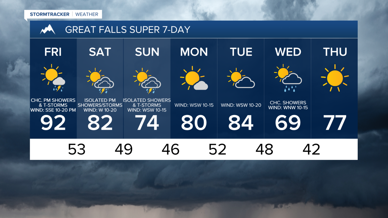
For tomorrow, we are going to have increasing PM clouds with some scattered PM showers and thunderstorms around as a disturbance passes through our area. Tomorrow is also going to be the hottest day of the next week as highs are going to be in the mid to upper 80s and low to mid 90s. It is also going to be breezy in a lot of areas tomorrow, especially during the afternoon and evening, as sustained wind speeds are going to be between 10 and 25 mph, and this wind is going to be coming out of the south or southeast in most locations.
We are then going to have partly cloudy skies this weekend with a few showers and thunderstorms around from Saturday afternoon through Sunday as a storm system works its way through our area. There are also going to be areas of haze around this weekend, especially on Saturday. We are also going to have a wide range of temperatures on Saturday as highs are going to range from the upper 60s to the mid 90s, with the coolest temperatures near the Divide and the hottest temperatures in northeastern Montana. It is then going to be cooler for everyone on Sunday as highs are only going to be in the 70s and low 80s.
It is also going to be windy on Saturday along the northern half of the Rocky Mountain Front as sustained wind speeds are going to be between 15 and 30 mph, and it is going to be breezy on Saturday along the Hi-Line, along the southern half of the Rocky Mountain Front, in the mountains, and in western portions of north-central Montana as sustained wind speeds are going to be between 10 and 25 mph. Also, this wind is going to be coming out of the west in a lot of locations. It is then going to be a bit breezy on Sunday as sustained wind speeds are going to be between 10 and 20 mph.
We are then going to have mostly sunny skies on Monday with some isolated showers around, mainly in locations east of I-15, as this storm system leaves our area. Increasing clouds and mainly dry conditions are then expected on Tuesday as the next storm system begins to approach our area. The temperatures are also going to warm back up some over these two days as highs are going to be in the 70s and low 80s on Monday and the upper 70s and low to mid 80s on Tuesday. It is also going to continue to be breezy in some areas on these two days as sustained wind speeds are going to be between 10 and 20 mph.
There are then going to be some scattered showers and a couple thunderstorms around on Wednesday, especially during the morning, as another storm system passes through our area. It is also going to be cooler and a bit breezy on Wednesday as highs are going to be in the mid to upper 60s and low to mid 70s, and sustained wind speeds are going to be between 10 and 20 mph.
Lots of sunshine, mainly dry conditions, little wind, and pleasant temperatures (highs in the 70s) are then expected on Thursday as high pressure is going to be in control of our weather.