A WINTER WEATHER ADVISORY is in effect for part of northeastern Montana from 12am until 2pm Friday.
A WINTER STORM WATCH is in effect for the Highwoods and Little Belts from 6pm Friday until 6am Sunday.

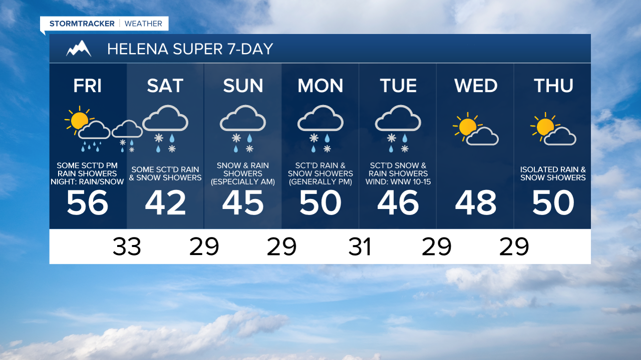
We are going to have partly to mostly cloudy skies tonight with some scattered rain, freezing rain, and snow showers around in north-central Montana and some isolated rain/snow showers around the Helena area. It is also going to be cool tonight as lows are going to be in the mid to upper 20s and low to mid 30s. There is also going to be a little breeze around tonight as sustained wind speeds are going to be between 5 and 20 mph.
For tomorrow, we are going to have increasing clouds around Helena with scattered rain and mountain snow showers around, generally during the evening. In north-central Montana, we are going to have partly to mostly cloudy skies tomorrow with some scattered rain, freezing rain, and snow showers around, generally during the morning and evening. It is also going to be a little breezy tomorrow in some areas as sustained wind speeds are going to be between 5 and 20 mph. The temperatures are also going to be a lot cooler tomorrow than they were today as highs are going to be in the upper 30s and low to mid 40s along the Hi-Line and the mid to upper 40s and low to mid 50s south of the Hi-Line.
There are then going to be areas of rain and snow around tomorrow night as a stronger disturbance begins to approach our area. On Saturday, we are going to have overcast skies with scattered snow and rain around throughout the day, especially in locations east of I-15, as this disturbance continues to impact our area. In the lower elevations, up to 3” of snow is possible in locations that do see some snow. In the mountains, up to a foot of snow is possible, but most areas will receive 2-8” of snow. The snow will cause the mountain passes to be slick at times, so please use caution if you are going to be traveling anywhere.
We are then going to have overcast skies on Sunday with snow/rain showers likely around Helena and some scattered snow and rain showers around in north-central Montana, especially during the morning, as Saturday’s disturbance leaves our area and as another disturbance begins to impact our area. It is also going to be chilly again on Sunday as highs are going to be in the mid to upper 30s and low to mid 40s.
Cool and wet weather will then continue early next week. On Monday and Tuesday, there are going to be scattered rain and snow showers around Helena, especially in the mountains, and there are going to be a few scattered snow and rain showers around in north-central Montana, generally in the mountains and in locations east of I-15. We are also going to have mostly cloudy skies and cool temperatures on these two days as highs are going to be in the 40s and low 50s. There is also going to be a bit of a breeze around on Tuesday as sustained wind speeds are going to be between 10 and 20 mph.
We are then going to have partly cloudy skies and mostly dry conditions on Wednesday as high pressure is going to briefly be in control of our weather. It is also going to be breezy and a little warmer on Wednesday as sustained wind speeds are going to be between 10 and 20 mph, and highs are going to be in the mid to upper 40s and low to mid 50s.