A RED FLAG WARNING is in effect for a lot of Montana until 9pm/12am Friday night. Critical fire weather conditions are currently occurring due to the combination of very warm to hot temperatures, gusty to strong winds, and low relative humidity, so please do your part to not start any new fires.

An AIR QUALITY ALERT is in effect for portions of western Montana until at least 12pm Saturday. The air quality is going to be unhealthy for everyone or unhealthy for sensitive groups at times.

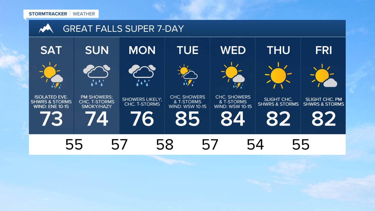
Widespread haze and areas of smoke will continue to impact Montana for the next few days. The air quality will fluctuate over the next few days as well. At times, the air quality will be good, while at other times the air quality will be unhealthy for sensitive groups or even unhealthy for everyone. Gradual improvement in the haze and smoke is expected as we head into early next week.
It is going to continue to be very windy this evening as wind gusts up to 50 mph are possible. Tonight, the wind will gradually weaken, but it is still going to be breezy, especially early on, as a cold front passes through our area as wind gusts up to 40 mph are possible. The wind will also be coming out of the west/southwest ahead of the cold front and the north/northwest behind the cold front. We are also going to have mostly clear skies tonight with some isolated showers and thunderstorms around in locations east of I-15, generally during the evening. It is also going to be a lot cooler tonight than it was last night as lows are going to be in the 40s and low to mid 50s.
For tomorrow, we are going to have partly cloudy to mostly sunny skies with scattered showers and thunderstorms around during the afternoon and evening in central and southern Montana, including around the Helena and Lewistown areas. In north-central Montana, a few isolated showers and thunderstorms are possible tomorrow evening. It is also going to be a lot cooler tomorrow than it has been over the past few days as highs are going to be in the 70s and upper 60s in most locations. There is also going to be a breeze around tomorrow morning in northeastern Montana as wind gusts up to 40 mph are possible, and there is going to be a bit of a breeze around in some areas tomorrow afternoon and evening as wind gusts up to 30 mph are possible.
On Sunday, rain will develop from south to north as the day goes on. Southern Montana will see the rain develop during the morning; central Montana will see the rain develop during the late morning and afternoon; and northern Montana will see the rain develop during the late afternoon and evening. Widespread precipitation is then expected Sunday night. Showers are then likely on Monday, especially during the morning and the evening. We are also going to have mostly cloudy to overcast skies on Sunday and Monday. A few thunderstorms are also possible on Sunday and Monday. This is also going to be a nice, soaking rain, which will help to contain some of the fires here in Montana.
It is also going to be cool on Sunday and Monday as highs are going to be in the mid to upper 60s and low to mid 70s in most locations. Breezy conditions are also expected on Sunday in locations east of I-15 in north-central Montana as well as in locations along the Hi-Line as sustained wind speeds are going to be between 10 and 25 mph, and wind gusts up to 40 mph are possible. It is then going to be a little breezy on Monday as sustained wind speeds are going to be between 5 and 20 mph.
There are then going to be some scattered showers and thunderstorms around on Tuesday and Wednesday. We are also going to have partly cloudy to mostly sunny skies and warmer temperatures on these two days as highs are going to be in the 80s in most locations. It is also going to be a bit breezy on these two days as sustained wind speeds are going to be between 10 and 20 mph.
Mostly to mainly sunny skies and mostly dry conditions are then expected on Thursday and Friday. We are also going to have pleasant temperatures on these two days as highs are going to be in the mid to upper 70s and low to mid 80s.