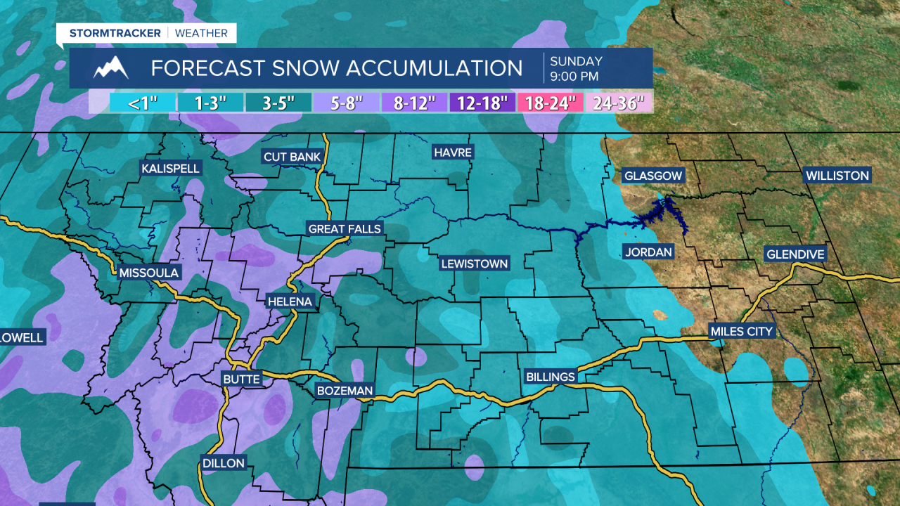
A WINTER WEATHER ADVISORY is in effect for the Rocky Mountain Front and some of the mountains in western, central, and southwestern Montana from 5pm/11pm Friday until 5pm Sunday. 3 to 6 inches of snow accumulation is expected, with higher amounts possible in the mountains.

We are going to have partly cloudy to mostly clear skies tonight with patchy areas of fog around along portions of the Hi-Line. It is also going to be mild again tonight as lows are going to be in the 20s and 30s in most locations. There is also going to be a little breeze around tonight around the Little Belts and in northeastern Montana as sustained wind speeds are going to be between 5 and 20 mph.
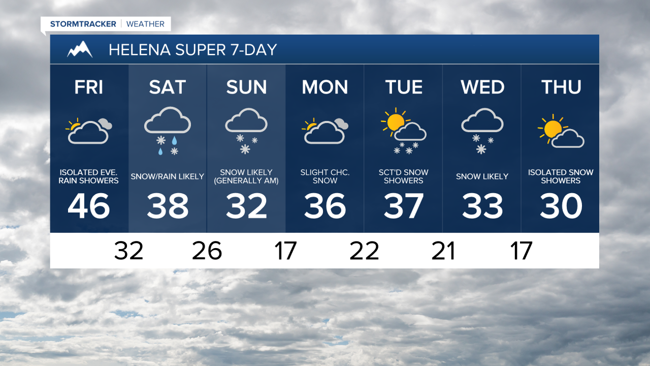
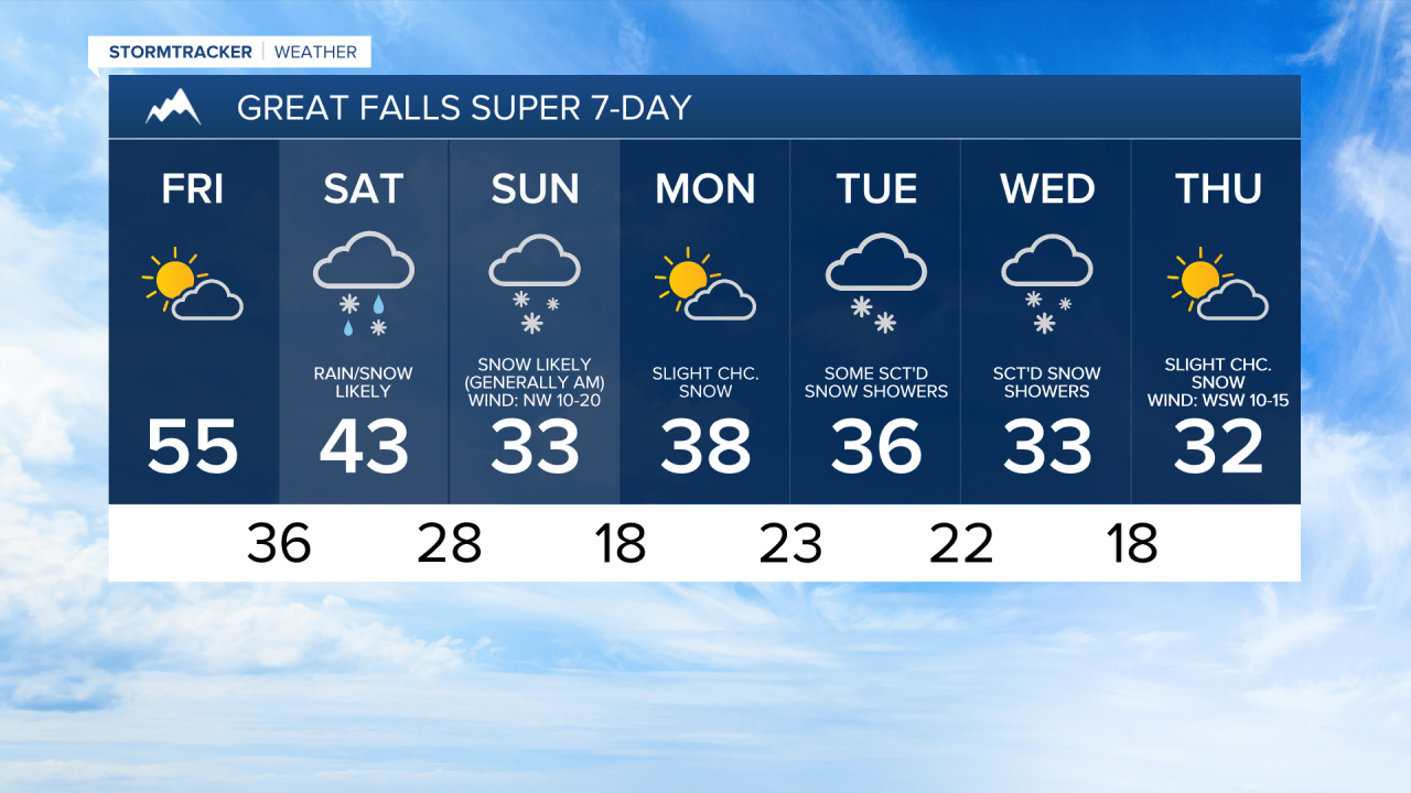
For tomorrow, we are going to have partly to mostly cloudy skies with some isolated lower elevation rain and mountain rain/snow showers around during the evening, generally around the Helena area, as a storm system begins to approach our area. The temperatures are also going to start to cool back down tomorrow as highs are going to be in the mid to upper 40s and low to mid 50s in most locations. It is also going to be a bit breezy tomorrow in northeastern Montana as sustained wind speeds are going to be between 10 and 20 mph.
Cooler and wetter weather is then expected this weekend as an upper-level trough is going to be in control of our weather. On Saturday, there are going to be areas of precipitation around throughout the day (especially in central Montana and western portions of north-central Montana), with the precipitation becoming more widespread as the day goes on. In the lower elevations, precipitation will start out as rain in a lot of locations, but this rain will eventually mix in with and switch over to snow as the day goes on.
Widespread precipitation is then likely Saturday night. This precipitation will be in the form of rain in northeastern Montana; rain transitioning to snow in central/eastern portions of north-central Montana; and snow in western portions of north-central Montana as well as around the Helena area. Snow is then likely on Sunday in north-central and central Montana, but this snow will gradually taper off as the day goes on. In northeastern Montana, rain, possibly mixing in with some snow, is likely on Sunday, especially during the morning.
There is still a lot of uncertainty with snow amounts for this weekend as how much snow we receive depends on how quickly the rain changes over to snow as well as how much snow initially melts on contact with the ground due to the warm temperatures that we have had here of late. Right now, I expect little to no snow accumulation in northeastern Montana, and 1 to 6 inches of snow accumulation in the lower elevations within central and north-central Montana (isolated spots may receive up to 8 inches of snow accumulation). In the mountains, 3 to 12 inches of snow accumulation is possible by the end of the weekend.

The temperatures are also going to cool back down this weekend as highs are going to be in the mid to upper 30s and low to mid 40s on Saturday and the 30s and mid to upper 20s on Sunday. We are also going to have increasing wind in northwestern portions of north-central Montana on Saturday, with more widespread breezy conditions expected Saturday night and Sunday as a cold front passes through our area. In many areas, sustained wind speeds are going to be between 10 and 25 mph.
On Monday, we are going to have partly to mostly cloudy skies with a few isolated snow and rain showers around. There are then going to be some scattered snow and rain showers around on Tuesday, especially in the mountains, and snow showers are likely on Wednesday as we remain in an unsettled weather pattern. A few more isolated snow showers are then possible on Thursday. We are also going to have partly to mostly cloudy skies on Tuesday and Thursday, and mostly cloudy skies on Wednesday.
It is also going to be cool next week as highs on Monday, Tuesday, and Wednesday are going to range from the mid 20s to the low 40s. Highs are then going to be in the mid to upper 20s and low to mid 30s on Thursday. The wind is also going to be on the lighter side for most of next week.


