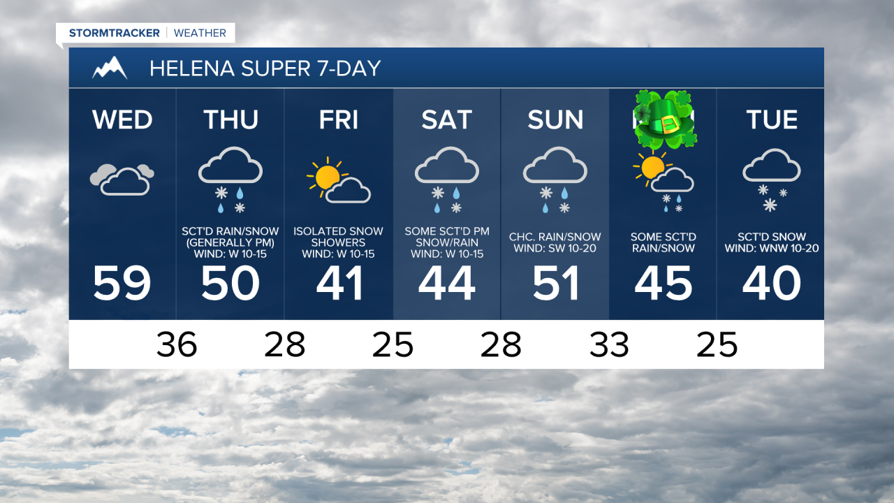
We are going to have mostly cloudy to overcast skies and mostly dry conditions tonight (just a few isolated rain and snow showers around). It is also going to be cool tonight as lows are going to be in the upper 20s and low to mid 30s in most locations. The wind is also going to diminish this evening, with little to no wind around overnight.
For tomorrow, we are going to have overcast skies and mostly dry conditions (just a few isolated rain and snow showers around). It is also going to be mild tomorrow as highs are going to be in the 50s in most locations. There is also going to be a breeze around tomorrow along the Rocky Mountain Front and in in central Montana as sustained wind speeds are going to be between 10 and 20 mph. Elsewhere, there is going to be little to no wind around tomorrow.
There are then going to be scattered rain and mountain snow showers around on Thursday, generally during the afternoon and evening, as a cold front passes through our area. Around Helena, it is possible that the rain may mix in with and/or switch-over to snow during the evening in the lower elevations. A stray thunderstorm is also possible with the passage of the cold front. We are also going to have partly to mostly cloudy skies (via increasing clouds) on Thursday.
It is also going to be gusty on Thursday along the Rocky Mountain Front as sustained wind speeds are going to be between 15 and 30 mph, and wind gusts up to 50 mph are possible. Elsewhere, it is going to be breezy on Thursday as sustained wind speeds are going to be between 10 and 25 mph, and wind gusts up to 40 mph are possible. It is also going to be mild again on Thursday in north-central Montana as highs are going to be in the 50s and low to mid 60s. Around Helena, it is going to be cooler on Thursday as highs are going to be in the 40s and low 50s.
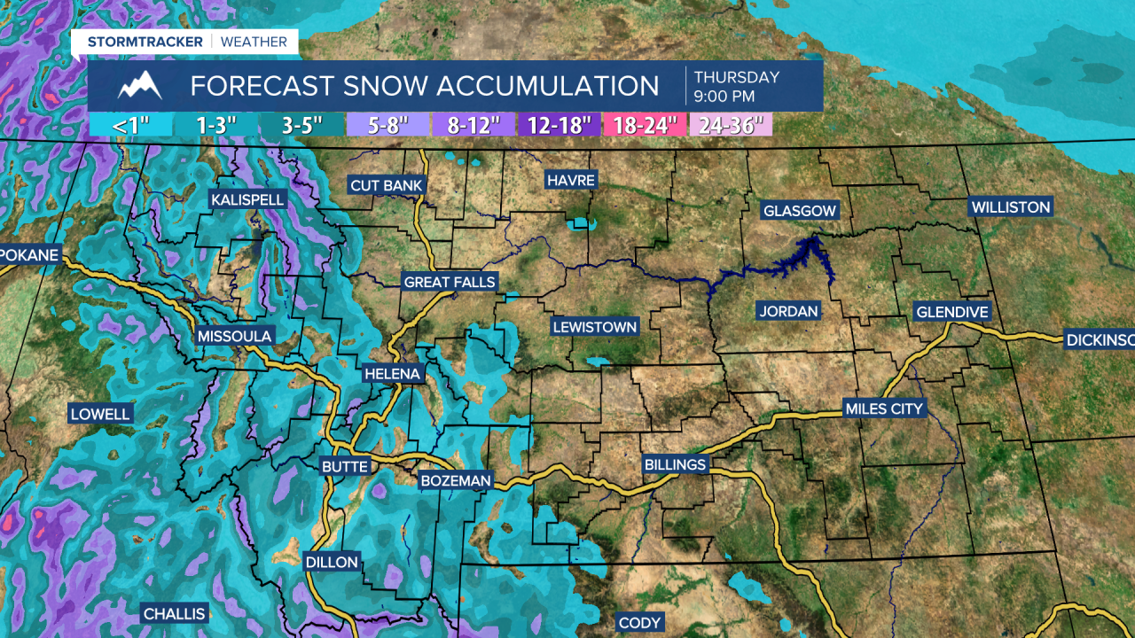
Through Thursday evening, most of the snow accumulation will be along and west of the Continental Divide, with some of the peaks possibly receiving up to a foot of snow. East of the Continental Divide, a coating to a couple inches of snow is possible in the mountains. In the lower elevations, little to no snow accumulation is expected. This snow will cause some of the mountain passes in western and southwestern Montana to be slippery at times, so please use caution when driving.
On Friday, we are going to have partly cloudy skies with a few snow and rain showers around. It is also going to be a lot cooler on Friday than it is going to be tomorrow and Thursday as highs are going to be in the mid to upper 30s and low to mid 40s in most locations. It is also going to be a little breezy on Friday as sustained wind speeds are going to be between 5 and 20 mph.
For this weekend, there is going to be some scattered snow and rain around the Helena area, generally during the PM hours and especially in the mountains, and there are going to be some isolated rain and snow showers around in north-central Montana, generally during the PM hours, as a couple disturbance pass through our area. It is also going to be breezy and cool on Saturday as sustained wind speeds are going to be between 10 and 20 mph, and highs are going to be in the mid to upper 30s and low to mid 40s. We are then going to have gusty winds around on Sunday as sustained wind speeds are going to be between 10 and 30 mph, and wind gusts up to 50 mph are possible. It is also going to be warmer on Sunday as highs are going to be in the mid to upper 40s and low to mid 50s.
We are then going to have partly cloudy skies on St. Patrick’s Day (Monday) with some scattered rain and snow showers around, especially in the mountains, as another storm system begins to impact our area. There is then going to be scattered snow and rain around on Tuesday as this storm system continues to impact our area. We are also going to have gusty winds around again on Monday as sustained wind speeds are going to be between 10 and 30 mph, and it will be breezy on Tuesday as sustained wind speeds are going to be between 10 and 20 mph. The temperatures are also going to cool down some over these two days as highs are going to be in the 40s on Monday and the mid to upper 30s and low 40s on Tuesday.