A WINTER STORM WARNING is in effect for the Highwood and Little Belt mountains until 11pm Friday.

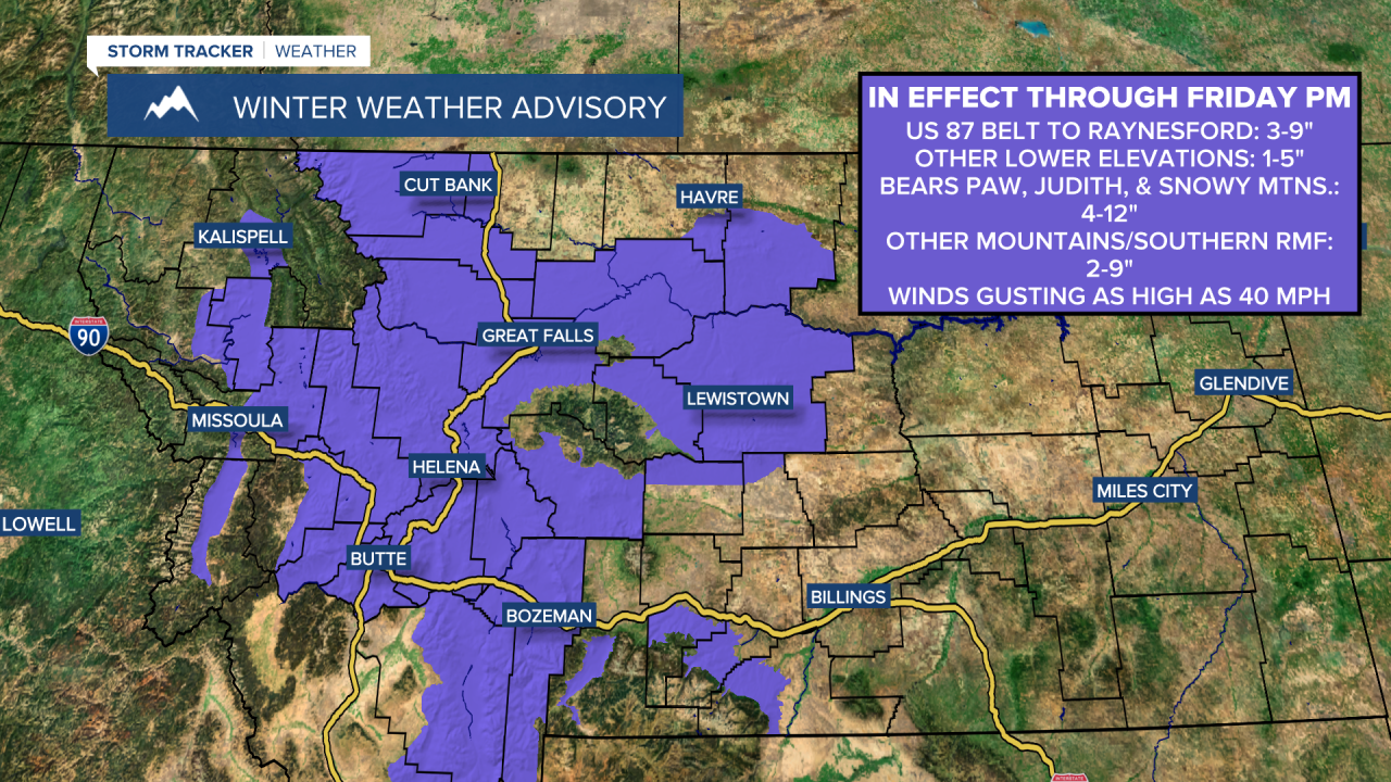
A WINTER WEATHER ADVISORY is in effect for a lot of western and central Montana through Friday afternoon/evening or early Friday night.

A cold front is going to bring widespread accumulating snow to much of the state tonight. This snow will initially develop along the Hi-Line during the evening and will work its way southward as the night goes on, reaching places like Great Falls and Lewistown between 9pm and 11pm and reaching the Helena area after midnight. Expect it to snow for a few hours with the passage of the cold front, and the snow may be moderate to heavy at times. By tomorrow morning, a lot of north-central Montana will be dry, but there will still be some scattered light to moderate snow around in central Montana (including around Great Falls, Helena, and Lewistown) as well as along the southern half of the Rocky Mountain Front. This steadier snow will taper off as the morning goes on. There are then going to be some scattered snow showers around tomorrow afternoon/evening and tomorrow night as the disturbance associated with the cold front continues to impact our area.
In the lower elevations, a coating-3” of snow is expected in most spots through Saturday morning, but along the Rocky Mountain Front, along I-15 between Great Falls and Butte (excluding the Helena Valley), and around the Lewistown area, that’s where 2-6” of snow is expected, and then along Highway 87 between Belt and Raynesford, that’s where 3-8” of snow is expected. In the mountains, 2-12” of snow is expected, with the highest amounts in the island mountain ranges in central and north-central Montana. Slippery road conditions are expected tonight and tomorrow due to this snow, so please use extreme caution when driving. It is also going to be a very slick Friday morning commute throughout much of the state, so give yourself some extra time to get to work and school.

Gusty winds (gusts over 40 mph) will continue this evening, but the wind will gradually diminish as the night goes on. However, in eastern portions of north-central Montana, it will be breezy for most of tonight with sustained wind speeds between 10 and 25 mph.
Blustery conditions are then expected tomorrow and tomorrow night in locations east of I-15 as wind gusts over 40 mph are possible at times. Around and west of I-15, it will be a little breezy tomorrow with sustained wind speeds between 5 and 20 mph. This wind will cause there to be areas of blowing and drifting snow as well as areas of reduced visibility, so please use caution when driving!
We are also going to have overcast skies tonight and mostly to partly cloudy skies tomorrow. It is also going to be chilly tonight and tomorrow as lows tonight are going to be in the mid to upper teens and low to mid 20s and highs tomorrow are going to be in the 20s and low 30s.
We are then going to have decreasing clouds, mainly dry conditions, and little to no wind around on Saturday as high pressure begins to build into our area. Saturday is also going to be the coldest day of the next week as highs are going to be in the upper teens and low to mid 20s.
On Sunday, we are going to have partly to mostly sunny skies and chilly, but warmer temperatures as highs are going to be in the mid to upper 20s and low to mid 30s. Gusty winds are also expected on Sunday as sustained wind speeds are going to be between 10 and 30 mph, with the strongest wind along the Rocky Mountain Front and around Cut Bank.
An upper-level ridge is then going to provide us with nice weather for most of next week as we are going to have lots of sunshine and mainly dry conditions. Near to above average temperatures are also expected next week as highs are going to be in the 30s and low 40s. It is also going to be breezy in a lot of areas next week as sustained wind speeds are going to be between 10 and 25 mph. Along the Rocky Mountain Front, gusty to strong winds are expected next week as sustained wind speeds are going to be between 15 and 30 mph. In the valleys, little to no wind is expected next week.


