


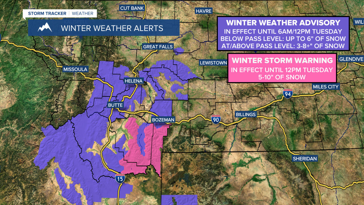
A WINTER WEATHER ADVISORY is in effect for portions of central and southwestern Montana until 6am/12pm Tuesday. Up to 6 inches of snow accumulation is possible below pass level, and 3 to 8+ inches of snow accumulation is possible at/above pass level.
A WINTER STORM WARNING is in effect for some of the mountains in southwestern Montana until 12pm Tuesday. 5 to 10 inches of snow accumulation is expected.
A FLOOD WARNING is in effect for the Milk River around the Glasgow area and around the Nashua area for a few to several more days. Minor flooding is currently occurring in these areas.

Rain and snow is likely tonight in southwestern and portions of central Montana (including around the Helena, Butte, and Bozeman areas), and there are going to be some scattered rain showers around tonight in north-central Montana. Snow levels tonight will drop as low as 4000-4500 feet, which means that the mountains, mountain passes, and some lower elevation locations will see some snow accumulation. A few isolated thunderstorms are also possible this evening and early tonight, especially in north-central Montana. We are also going to have mostly to partly cloudy skies tonight, with the cloud cover decreasing from north to south, especially during the second half of the night.
It is also going to be cool tonight as lows are going to be in the 30s and low 40s. There is also going to be a breeze around tonight in northeastern Montana and along the Rocky Mountain Front as sustained wind speeds are going to be between 10 and 20 mph.
For tomorrow, we are going to have partly cloudy skies with some isolated rain and snow showers around during the morning around the Helena area and a few isolated rain showers and thunderstorms around during the afternoon and evening east of I-15. It is also going to be breezy tomorrow in portions of central and north-central Montana as sustained wind speeds are going to be between 10 and 25 mph, with the strongest wind along the Rocky Mountain Front. We are also going to have pleasant temperatures again tomorrow as highs are going to be in the mid to upper 50s and low to mid 60s.
On Wednesday, we are going to have partly cloudy skies, dry conditions, and pleasant temperatures as highs are going to be in the low to mid 60s in most locations. It is also going to be breezy on Wednesday in portions of central and north-central Montana as sustained wind speeds are going to be between 10 and 25 mph
There are then going to be scattered rain showers and mountain snow showers around on Thursday as a disturbance passes through our area. We are also going to have gusty winds around on Thursday as sustained wind speeds are going to be between 10 and 30 mph, and wind gusts over 40 mph are going to be possible at times. It is also going to be cooler on Thursday than it is going to be over the next couple of days as highs are going to be in the mid to upper 40s and low to mid 50s.
Partly cloudy skies and mostly dry conditions are then expected on Friday, and mostly sunny skies and dry conditions are expected this weekend as high pressure is going to be in control of our weather. The temperatures are also going to warm up some over these three days as highs are going to be in the upper 50s and low to mid 60s on Friday and the 60s and low to mid 70s this weekend. There is also not going to be much wind around on these three days.


