


BILLINGS- The National Weather service issued a tornado warning Saturday night for Northeastern Montana for an area near Poplar, in Roosevelt County.
The warning from the NWS stated:
* Tornado Warning for…
Southeastern Daniels County in northeastern Montana...
Western Roosevelt County in northeastern Montana...
West central Sheridan County in northeastern Montana...
Northern McCone County in northeastern Montana...
Northwestern Richland County in northeastern Montana...
* Until 800 PM MDT.
* At 721 PM MDT, a funnel cloud was located 11 miles northeast of Wolf Point, moving northeast at 45 mph.
HAZARD...Damaging tornado and quarter size hail.
SOURCE...Law enforcement reported a funnel cloud at 722 PM.
IMPACT...Flying debris will be dangerous to those caught without shelter. Mobile homes will be damaged or destroyed. Damage to roofs, windows, and vehicles will occur. Tree damage is likely.
* This tornadic thunderstorm will remain over mainly rural areas of southeastern Daniels, western Roosevelt, west central Sheridan, northern McCone and northwestern Richland Counties.
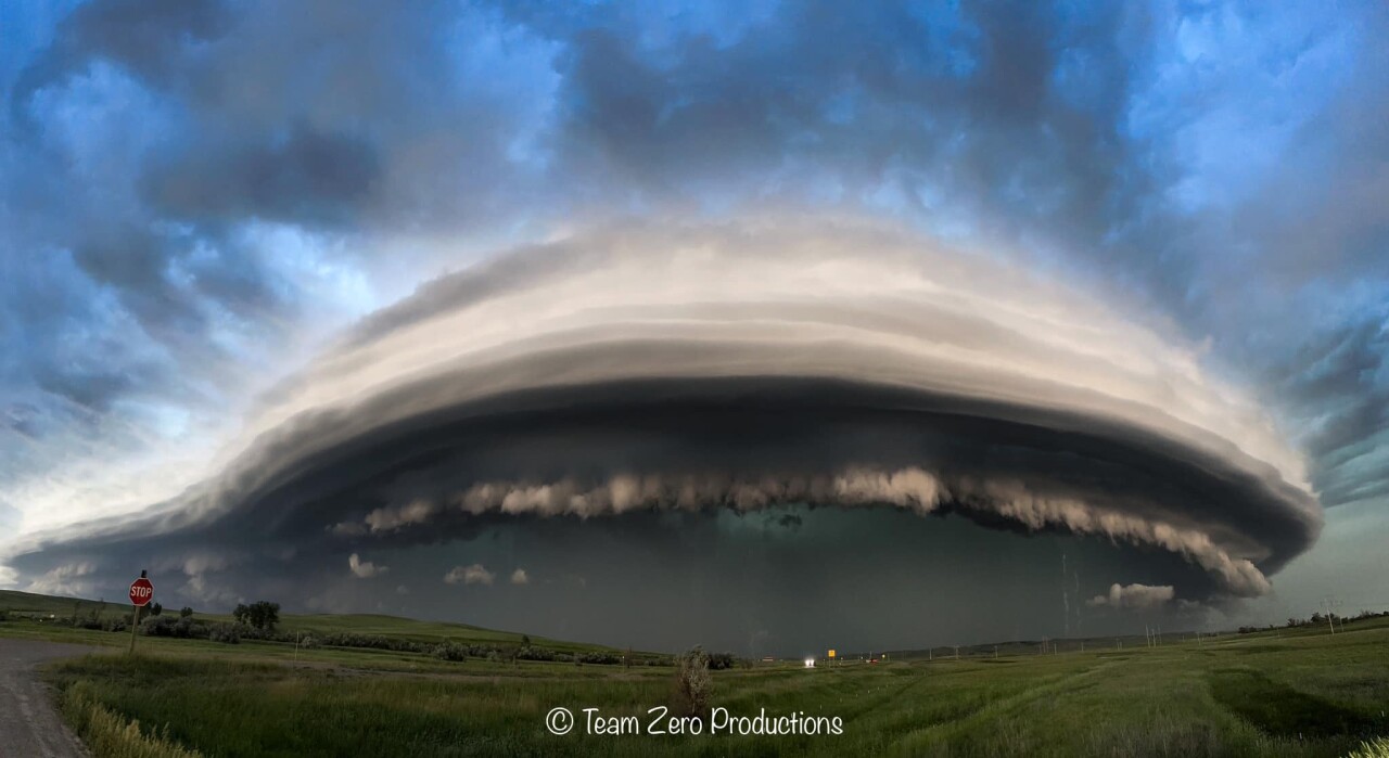
And while confirmation of an actual twister touching down is still to be determined, Jaden Pappenheim - a Michigan-based storm chaser - took the opportunity to head to Montana for the chance at a glimpse.
And in doing so, caught some incredible images of the storm.
Pappenheim tells MTN News that the tornado warning in Poplar will go down in history for him.
“It was just an incredible experience,” he said.
Not only for the images he saw in the sky, as the thunderstorm formed above Montana and into North Dakota, but also for the interaction he got with the locals during the storm.
“A truly an incredible experience,” he said. “It’s only happened to me a couple of times where the live stream will go berserk, and it reached the local audience.”
He travels the country, during storm season, but says whenever there’s something to possibly see in Montana, he goes the extra mile.
“Ever since I started chasing, I’ve always loved Montana and North Dakota,” said Pappenheim.
He’s been chasing for five years and already has over 50k social media followers, he says when the live stream started rolling during Montana’s tornado watch, at one point he had as many as 900 views at the high points.
And he heard about it.
“(They said) I am here, or you just passed me, or you pull up to a gas station and someone says, I am watching your life stream,” he said.
Even befriending a local deputy, also watching the storm unfold and watching Pappenheim's live stream.
As for the storm, Pappenheim says, he never actually saw a tornado touch down, but can understand why it was made.
“There were a lot of sheer funnels happening along the forward gust front and I think an emergency manager probably saw that funnel and reported it as a tornado and that’s what got the confirmed issue on it,” he said.
He chased the storm the span of 100 miles and says he eventually let it ‘run him over’ when it got dark. However, he also says, he experienced intense winds with the storm.
“Damaging winds for sure I know there were a lot of 70 mph gusts at airports,” he said. “Trash cans were blowing everywhere and even saw a couple power flashes.”
When MTN News spoke with Sunday afternoon Pappenheim he was already well on his way out of Montana and arriving in Minnesota to chase yet another storm.
But he says, should another tornado warning be issued in Montana, he can’t wait to come back.
“Just an incredible experience.”
